The Town of Aigio / Vostitsa
Companion for THDD episode 2.14
The town of Aigio (AKA Vostitsa), has evolved since ancient times, yet traces of older remains can still be found. This is a collection of plots, maps, photos, and textual sources to accompany the episode of The Helonaki Deep Dive on Aigio.
Pictures of Aigio in 2022
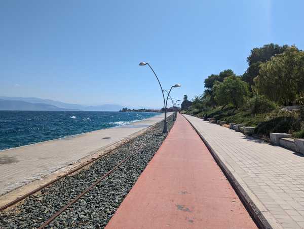
The old train tracks in Aigio are between the harbor and the new walking path.
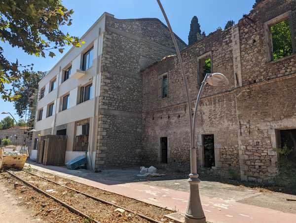
Some warehouses along the Aigio waterfront have been rehabilitated and are in use, while the rest are in various stages of disrepair.
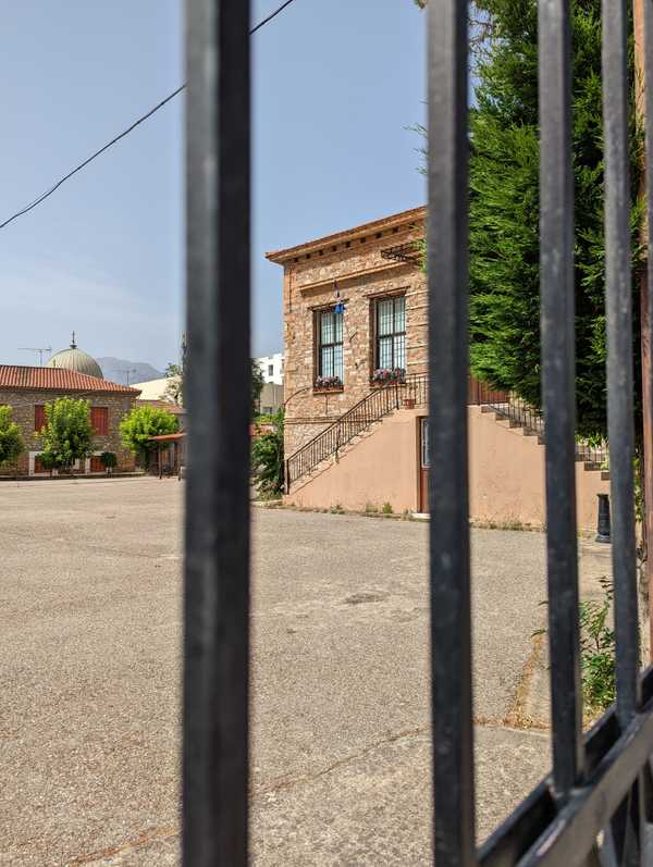
An old stone house from the 1800s has become the city historical museum. Unfortunately it was closed during my visit to Aigio.
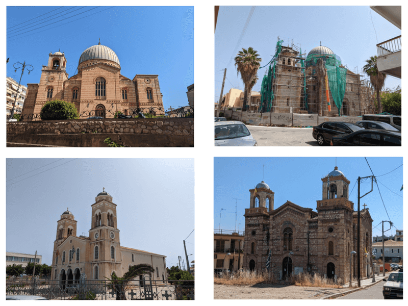
Four churches in Aigio. From top-left, clockwise: Aghios Faneromeni, Aghios Theotokou, Aghios Andreas, and Aghios Taxiarchon. All of the churches except for Aghios Andreas are all in the 1700 Venetian map of Vostitsa. Aghios Andreas is in the part of town known as Galaxidi, which was settled in the early 1800s.
Georeferencing the 1700 map
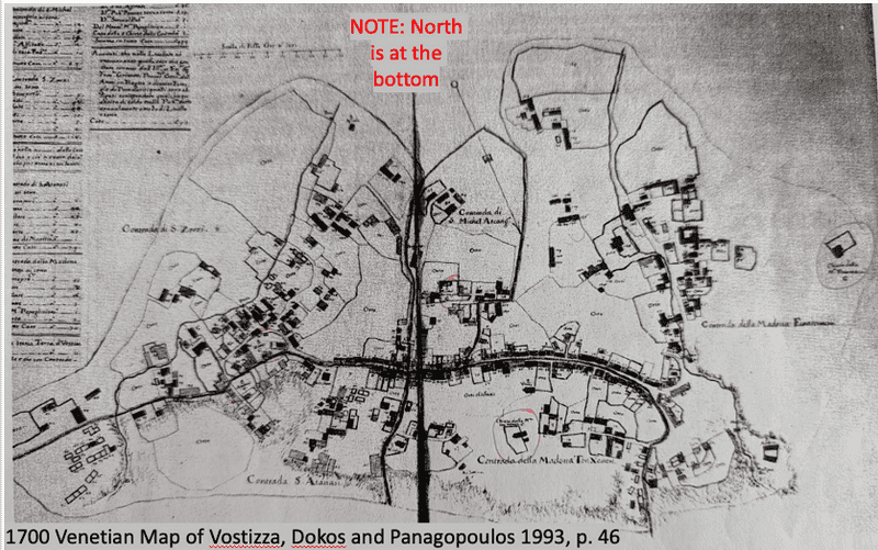
A map of the town of Vostitsa from 1700 was included among the Venetian cadastral records and was published with them by Dokos and Panagopoulos in 1993.
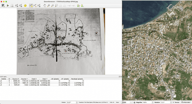
The georeferencing process was done using qGIS and consists of matching locations from the 1700 map with places on a present-day map.
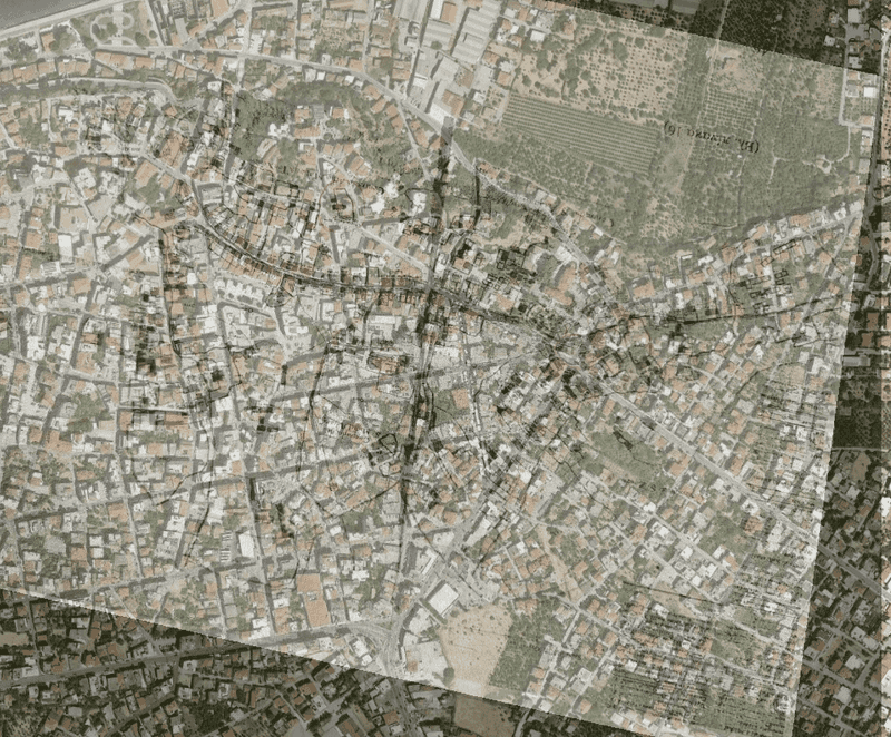
The end result of georeferencing is the older map overlaid on the modern map. The process usually takes a few iterations to get right.
Pausanias' description of Aigio
The description of Aigio or Aegium starts at 7.23.5 and continues through 7.24.4 in Pausanias 1918 on Perseus website.
Chronicle of Morea
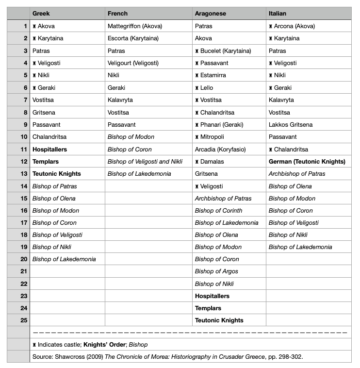
Locations mentioned in the 4 versions of the Chronicle of Morea. The 4 versions are Greek, French, Aragonese, and Italian. Based on translations of the four versions in Shawcross 2009, pp. 289-302.
Middle Ages Peloponnese
Peloponnese_Middle_Ages_map-fr.svg: Eric Gaba derivative work: Constantine ✍, CC BY-SA 3.0, via Wikimedia Commons
Western European traveler images of Vostitsa/Aigio
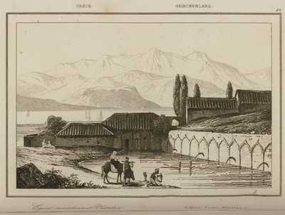
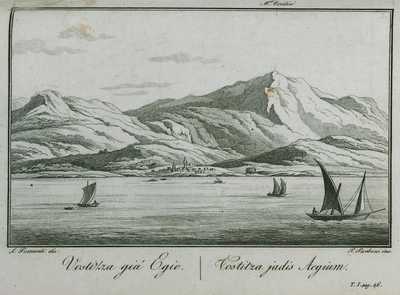
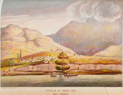
Aigion in 1823. in BLACK, William L.R.C.S.E. Narrative of Cruises in the Mediterranean in H.M.S. “Euryalis” and “Chanticleer”, during the Greek War of Independence (1822-1826). With an Appendix on the Climate, and Meteorological and Nosological Tables. Two coloured and eighteen half-tone illustrations, Edinburgh/London, Oliver and Boyd/Simpkin, Marshall and Co., 1900. From the Travelogues website.
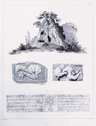
1. Cave of the oracle of Heracles Vouraikos close to Aigion 2. Medieval relief seen by the author in Aigion. 3. Ancient relief seen by the author at church in Aigion. 4. Inscription seen by the author at the now-lost church of the Presentation of the Virgin (Eisodia Theotokou), Aigion. Today a building by Ernst Ziller stands on the site of the church. in BLOUET, Guillaume-Abel. Scientific expedition to Morea, Ordered by the French Government: Architecture, Sculptures, Inscriptions and Views of the Peloponnese, the Cyclades and Attica, measured, drawn, collected and published by Abel Blouet, Architect, Director of the Architecture Section and Sculpture Expedition, Former Resident of the French Academy in Rome; Amable Ravoisié and Achille Poirot, Architects; Félix Crézel, History Painter, and Frédéric de Gournay, Literary. Work dedicated to the King, vol. I-VI, Paris, Firmin Didot, 1831-1838. From the Travelogues website.
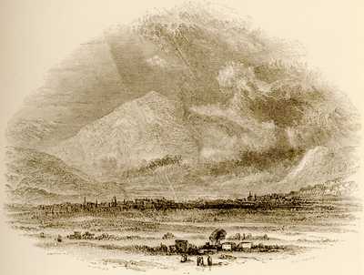
Town of Aegium in Achaia in WORDSWORTH, Christopher. Greece pictorial, descriptive, & historical by Christopher Wordsworth, D.D. Lord Bishop of Lincoln, with numerous Engravings illustrative of the Scenery, Architecture, Costume, and Fine Arts of that Country and a History of the Characteristics of Greek Art by George Schraf, F.S.A. Director, Keeper, and Secretary of the National Portrait Gallery. A New Edition revised. With Notices of recent Discoveries by H.F. Tozer, M.A. Fellow and Tutor of Exeter College, Oxford, Author of the “Highlands of Turkey”, “Lectures on the Geography of Greece”, London, John Murray, 1882. From the Travelogues website.
Aigio/Vostitsa Population
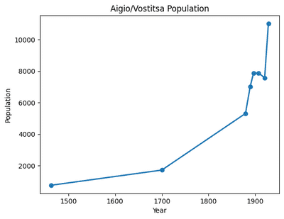
Population in Aigio has mostly trended upwards, except between 1907 and 1920, although the time periods of time between population totals until the censuses conducted by the modern Greek state hide fluctuations in population.
Aigio/Vostitsa Neighborhoods
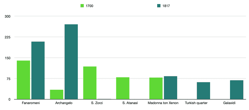
Buildings per neighborhood in Aigio/Vostitsa from 1700 Venetian cadaster and 1817 report on earthquake damage. Note that there is no record of Turkish quarter or Galaxidi in 1700 records and no record of S. Atanasi in 1817. There is only 1 building in the S. Zorzi neighborhood in 1817, and that is the very old church of S. Zorzi.
Bibliography
Dokos, Konstantinos., and Georgios D. Panagopoulos. To Venetiko ktematologio tes Vostitsas. Athena: Morphotiko Institouto Agrotikes Trapezas, 1993.
Liakopoulos, Georgios. The Early Ottoman Peloponnese: A Study in the Light of an Annotated Editio Princeps of the TT10-1/14662 Ottoman Taxation Cadastre (ca. 1460-1463). London: Gingko, 2019.
Μονιουδη-Γαβαλα, Δωρα. Πολεοδομια στο ελληνικο κρατος, 1833-1890: Αθηνα, Ερμουπολη, Μεσολογγι, Αγρινιο, Αιγιο, Σπαρτη. Urban planning in the Greek state, 1833-1890: Athens, Ermopouli, Mesolonghi, Agrinio, Aigio, Sparta. 1. ekd. Agrinio: Εκδοση Τμηματος Διαχειρισης Πολιτισμικου Περιβαλλοντος και Νεων Τεχνολογιων του Πανεπιστημιου Δυτικης Ελλαδας, 2012.
Shawcross, Clare Teresa M. The chronicle of Morea historiography in Crusader Greece. Oxford: Oxford Univ. Press, 2009.